17-2009
Lake Louis to Jasper
Jasper National Park
Icefields Parkway
I was eager to begin the next leg of my journey which would take me along the Icefields Parkway hwy 93 heading north west. I’m not sure what is more exciting, heading north into the unknown (at least for me anyway) or knowing that one of the stops was going to be the Columbia Icefield. I’m almost getting used to the enormity of the Rocky Mountain range up here, but with every mile I drive, they seem to become bigger and more awesome. I’m able to see the dozens of glaciers that sit high on many of the mountains, too numerous to list them by name.
There are so many turn-outs along the way, that I’ve started out fairly early this morning so that I don’t feel rushed and will have the time to stop and check out as many of the points of interest as possible.
See Picasa photos:http://picasaweb.google.com/douglas.palosaari
One of the first turn-outs was for Crowfoot Glacier. The glacier once had three toes, but now is down to two. Even with that it’s one impressive sight. I pass over Bow Summit which is the highest point for the park way road at 6,785 feet. I assure you the mountain ranges are much higher. I passed the weeping wall, a huge black granite wall with layers of water dripping down it’s sides. But the excitement builds knowing I’m getting closer to the Icefields.
Before I could get to them though, I had to endure mile upon mile of smoke filled parkway as they have been doing a prescribed burn along the route. The smoke was thick and if it is wasn’t for the fact that the scenery seems to go on without end, I didn’t feel I had missed much going through the miles of misty smokey mountainous terrain. Keep in mind that except for the three Park towns and a few Chateaus along the pristine lakes it is all wilderness along the 230 km of parkway.
I keep passing signs that say, “You are now leaving Avalanche terrain”… when did it begin? I never did see the first sign. Before I knew it, there was another sign, “You are now leaving Avalanche terrain”. Well not to worry, most of the snow is off of the mountains directly against the highway.
See Picasa Photos: http://picasaweb.google.com/douglas.palosaari
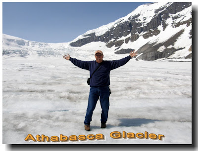
Finally I reach the Columbia Icefields where I took one of the large snowmobiles rides onto the Athabasca Glacier. A bit pricey at $49c but it’s something that’s definitely been on my things to do before I die list. The Glacier has receded considerably from mid 1800’s when it once covered the valley, parkway and current parking lot across the valley. The vehicle with it’s tires that are almost 5 feet high drove us up and onto the glacier which is over 1,000 feet thick, past the lateral moraines (those are huge piles of stone and rubble deposited by the glacier as it receded). It was an unusually warm day as we walked out onto the ice field, which was puckered with the melting of the surface ice. Small streams ran along the boundary where we were safe to walk around on it. We were even told we could drink from the clear glacier streams. How cool is that. A cool breeze descended on us as the colder air was pushed down along the glacier. I could hear small avalanches high up along the sides of the mountains that bordered the glacier and was even able to see a few puffs of snow as the avalanches tumbled down and over the rocks. Not big enough to get a good picture of, but still exciting to hear and see.
Ok, so that was really exciting for me. I continued along the Icefields Parkway, stopping numerous times to view alpine lakes, the longest stretch of unbroken Rocky Mountain range in the Americas and past a half dozen waterfalls. My favorite was Angel Falls which wasn’t even listed on the Points of Interest map that showed just a ton of things to see along the route. It dropped from a rock precipice creating a sheet of water that dropped down away from the rock wall,
creating a perfect wall of water until finally hitting bottom and then cascading down yet another cliff.
Tip for Campers: I discovered that my Visa Debit card appears not to charge an exchange transaction fee when making purchases. My Visa Credit card does, which could wipe out any dollar to Canadian dollar exchange rate benefit especially on smaller purchases. Check yours out the next time you enter Canada. It could end up saving you a bit of money.
Today was one of those days when everything worked out perfectly. To start, after checking with the Visitor Center here in Jasper, I found out that unlike Lake Louis, almost all of the ATM’s accept Visa cards. I walked over to the CIBC bank and was able to use their ATM to get cash out with my Visa Debit card. Cost for using their ATM, 69 cents. What a deal. And you know I love a good deal.
A couple days later I tried another local bank, Canada Trust. I was able to get money out of my Visa Debit card, but I noticed my bank in the U.S. charged me a $2 transaction fee. Something you only find out about after you use a banks service. For me, CIBC is my best choice when getting cash out of an ATM machine. Good to know.
Then I was told of two places where I could get Internet access, the local Library and LouLou’s Pizza. Since it was early morning, I decided to check out the Library first. They had access for $2.50c for one hour. Worked out pretty well as I was able to upload my Blog, check mail, bank accts etc. And it did take a full hour.
For lunch I hit LouLou’s and as long as you order a meal, the Internet access is free. Wow, that’s my price. So after having lunch, I was able to upload all my pictures from the past week and a half to my Picasa site. Felt really good to get those pictures up and loaded so you could see some of them. And no, I didn’t upload all of them, there are just to many.
Did a bit of shopping in town and will do my grocery shopping tomorrow as well as laundry since I found both places today. Life is so hectic. There’s always something that has to be done eh. When will I get to do more touring? Well it’s actually nice to do some ordinary projects once and a while.
Have I mentioned that it really stays light out late into the night. The sun sets around 9:30 and it’s still light out until about 11 pm.
You know the other day when I was visiting with Laurel we talked about the towns that are a part of the National Park of Banff, Jasper and Yoho. She was telling me that in Yoho National Park, the town is called Field. To live there, one has to have proof of need I think is the way she put it. In other words, one has to have a need to live in the area due to a job or other circumstances to be able to purchase or lease a place. All the land is of course owned by the Gov. One of the reasons this is the case is so that the wealthy, super rich, don’t move in and take over the towns, leaving no place for the workers to live. She gave an example of some friends who split up, the husband has a job in the Park and the mother has a new baby. He has the right apparently to keep the house, so what does the mother and child do?
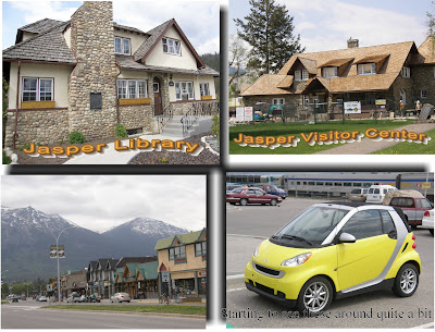
While I’m here in Jasper for a couple of days, taking care of all those chores one has to do, like laundry ($4c for wash and $2c to dry), grocery shopping etc. I’ve been noticing that the town almost seems too perfect. There are no run down buildings or homes. All the shops and restaurants are tidy perfect little places. I’m not used to that. Somehow life isn’t that perfect and it seems out of place. And oddly not perfect like Disney World either. Beautiful to be sure and I love the buildings with there large log and field stone construction.
It is nice to see the Canadian Pacific Railroad so active throughout this area. Both for freight as well as passenger service. Jasper has a large train station right opposite town and it is kept busy with trains coming and going all day (and probably all night). Banff and Lake Louis do as well.
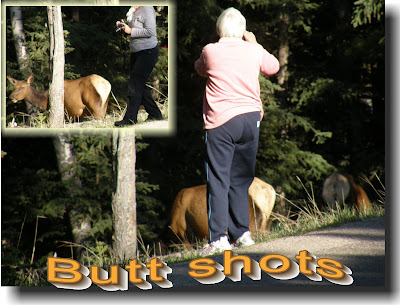
Sometimes one wants to get the best pictures one can but it doesn’t always work out. This morning on my mission to get some chores done, I was heading out of the campground I’m staying in, and their were a couple of Elk near the entrance. I’ve got an eagle eye and see these things, especially when everyone is parked and standing around with cameras in hand taking pictures. Well as it turned out, the tourists, and it appeared to be many were Canadians though I’m making assumptions that may not be true, were all getting as close as they possibly could to get their pictures. Don’t they have zoom lenses? I was staying back across the street trying to get at least one good shot and about all I got was a lady’s butt along with the shot of the Elks butt. And they were both less than 8 feet from each other. Geez, people, upon enter the park there are signs everywhere warning that this in rut season and to stay away from the Elk in particular as they get very uppity about strangers getting close to them. I think it must have been too early in the morning for these elk and they probably hadn’t even had their first cup of coffee and weren’t really awake. Because they just gradually moseyed along back into the forest. Personally I would have liked to have seen some butt kicking myself.
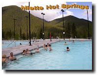
As I headed out of Jasper, heading east for a bit, towards Hinton and Edmonton a couple hours further east, my mind was thinking of those hot springs, Miette Hot Springs which are about 30 miles out of town. I hadn’t asked anyone about the roads leading into the hot springs and ended up taking my 5th wheel camper and truck along a super winding road though some mountain regions for about 12 Km. But not to worry, the truck handled those mountain grades with ease and before you knew it, I was at Miette Hot Springs. They have a newer facility containing two large swimming pools with concrete benches along the pools edges for sitting and absorbing those wonderful mineral rich hot springs. A must for anyone heading up to Alaska.
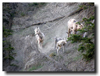
Ahhhhh, the deep heat of those hot springs is just what I needed before beginning my North North West journey with a stop in Grande Cache. My last views of those magnificent Rocky Mountains. One of the last great mountain peaks I would see is the Grande Roche Miette which appears to be the tallest and biggest looking mountain I’ve see to date. It is however only 2,316 Meters high, (many of the others were in the 3,000 to 3,500 meter range) actually not the highest by any means, but perhaps the way one comes across it along hwy 16, those sheer dark granite walls look so massive, I just can’t help but be impressed. Then along the highway, I once again had my eagle eye on the lookout and sure enough, after stopping along the side of the road (where about 4 other cars had stopped) there were about 8 mountain goats scampering along the steep cliff. A couple of young goats were jumping and dashing around so much so, they were stirring up quite a bit of dust and rock. Fun to watch.
Taking the “scenic” route hwy 40, which is quite redundant to say around these parts as every view is scenic. I’m starting to really get that way up north feeling. I did see two elk with their antlers just starting out, so I’m assuming they were young bucks. There’s supposed to be large numbers of Caribou but I haven’t seen any yet. By the way, scenic also usually refers to smaller country roads and this one fit’s the bill. Tons of logging operations along through here, but it doesn’t appear to have scarred the landscape like so many logging operation can do. Probably because there are just so many stands of those Douglas Firs and Lodge Pole Pines that one hardly misses a patch of them here and there. I’ve stopped overnight at Grande Cache on top of a plateau, a small town with a surprisingly active shopping mall. 4 long buildings around a large square parking are. Each building is like an inside strip shopping mall. Gas stations and Motels with restaurants line the main drag.
I’ve got 196 miles to go and I’ll be at the start of the Alaskan Highway, Dawson Creek. It’s just over the Alberta/British Columbia boarder. The excitement is really building. I’ll be switching over to my British Columbia maps and camp guides ready for the big push up into Alaska.
The Adventure Continues....
No comments:
Post a Comment